DEFRA large Scale Flood Map of Freshford Mill |
|
|
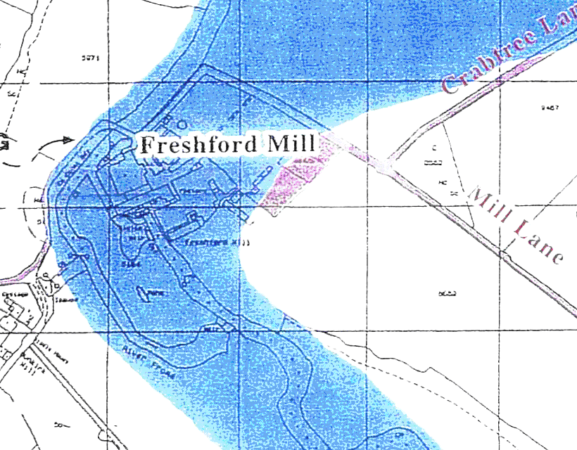
The Relationship Between the Large Scale DEFRA Map & Online VersionThe DEFRA large scale map above clearly shows that the site is well inside the flooded area and NOT as depicted in the DEFRA website map as being opposite Crabtree Lane. The Internet DEFRA flood search maps would be those that people would refer to when looking for a safe place to live. Once you've found the page a search can made by entering a post code or a town. It is a very good resource, but only if it is accurate. Why is there an Error?DEFRA's mapping facility is based on maps supplied by the Ordnance Survey. Unfortunately it appears that the mapping was derived from the 1:50,000 series maps. (refer to Flood Maps) Rather than the 1:25,000 series. This makes no sense as surely the more detailed mapping needs to be used to ensure a more accurate location of the buildings. Someone made a serious mistake, as this type of error must be happening on the mapping of the whole country. The correspondence from the CEO of DEFRA and the Ordnance SurveyWhat was in the mind of the person who should have been studying this map when it was being prepared, was it derived from film? Why hasn't it been corrected? There are those that may say, my complaint has been lost. Lost? I doubt it because I wrote directly to the Chief Executive Officers of both DEFRA and the Ordnance Survey and received personal letters from both CEO's so they believed that my complaint was sufficiently important to write to me personally and I was also visited by two officers from DEFRA later. The DEFRA map has been altered to show the legend: "Mill" rather than as was previously labelled "wks" unfortunately the actual location of the Freshford Mill has remained in the wrong place and is now even more misleading!. Perhaps it is realised that the whole mapping that has been prepared for DEFRA will need to be scrapped or removed from the Internet and replaced by a more accurate tool. The Ordnance Survey Maps were Altered in 1991The map that was used by the Environment Agency for the development of the Flood map facility was the Ordnance Survey 1:50 000 scale 1991 edition. Earlier editions show Peridins and Freshford Mill almost correctly for this scale of map . Freshford Mill OS Maps The map above is part of the Freshford Flood map, a copy of which is attached, at the very bottom of the lengthy Freshford Parish Council Comments page |