Comparison of OS Maps 172 at Freshford Mill (Peradins) |
||
Flood Map Errors: CEO Barbara Young's StatementBarbara Young has denied in a recent letter to the Right Honourable Anne McIntosh MP Shadow Minister for the Environment that there is an error in the Environment Agency's flood mapping for Freshford Mill. She has also explained that the agency uses the most appropriate Ordnance Survey's mapping (1:50 000) on their website to put Environment Agency data in its geographical context and that . . .'we are not responsible for the production of OS maps.' Whilst I don't know whether there is an error at Freshford Mill or elsewhere in the agency's flood contour mapping there is quite definitely an error in the location of the mill complex, or more accurately an ambiguity. As this is geographical data I have researched the map data available to the Environment Agency which is provided by the Ordnance Survey. |
||
|
|
 |
|
Flood Map for the Freshford Mill Location 2008 |
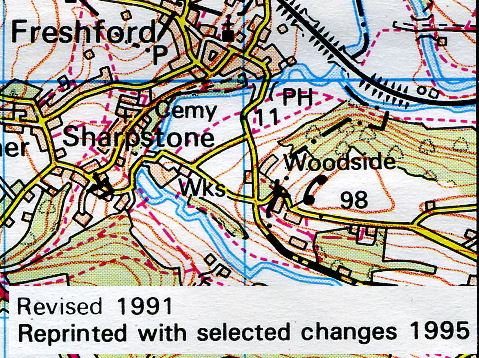
Ordnance Survey map of Freshford Mill Location 1995 |
|
| It is quite clear that comparing the Environment Agency's flood map to the Ordnance Survey's (OS) the Agency has used the data they were supplied with. I am surprised that Barbara Young is satisified with the maps she has been provided with. The map extract refers to the Revised 1991 edition Reprinted with selected changes in 1995. It was during this timescale that the estate known as either Freshford Mill or Peradins locally was going to be sold. The OS mapping appears to depict the building complex as being opposite Crabtree lane whilst this is simply not true. Whilst as we all know a map is not an aerial photograph there is a remarkable correspondence between what we know to be there on the ground and what is depicted in the map. I live locally and I can assure the reader that the depiction of many of the buildings and groups of buildings is correct in OS map 172 even though there is a simplification to the boundary shape of small dwellings relative to the small scale of the map. So why has the OS depicted the complex of buildings known as Peradins or Freshford Mill so poorly? | ||
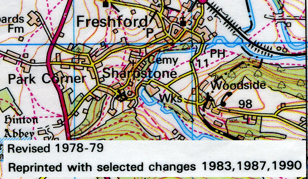 |
Vanessa Lawrence CEO of the OSThis is an extract from the same Landranger map No 172 Bristol, Bath & surrounding area. However, this map was produced in the late 1970's with revisions to 1990. It is therefore, the mapping that should have been used by DEFRA as the complex of buildings known as Freshford Mill, or Peradins is depicted in the right place. But the Ordnance Survey provided a 'new' mapping for the UK Flood Map facility. Why did the OS alter the mapping of this part of our countryside? Who decided to re-locate the 'Wks' higher up the hillside, out of the flood plain? Vanessa Lawrence, the current Director General and Chief Executive Officer of the Ordnance Survey has refuted the evidence that Freshford Mill or Peradins has been re-located to an inappropriate place. She has argued in a letter to the Right Honourable Anne McIntosh MP (Shadow Minister for the Environment) that 1 mm on this scale of map represents 50 metres on the ground (well that's what a scale of 1:50 000 represents) and so she argues the error in the location of the mill complex is to be accepted. |
|
|
And why recommend that this scale of mapping should be appropriate for
the Environment Agency in producing its flood maps if it is only accurate
to 50 metres? But why did the OS alter the mapping in map 172 to
that above anyway? My cottage is in the right place in this map,
local footpaths are correctly located as is the local school. So why is
this large
group of buildings mapped in the wrong place -when in the mapping of 1978-79 shown
on the left they are depicted correctly?
The reason appears to be that a new building was built after OS 172 edition 1978-79 was published. This new building is a very large, mainly made of steel, and it would seem that the cartographer who made the changes to the new revised edition of OS 172 in 1991 tried to add the new building to the existing generalised building cluster. There is not enough room to do this, so the cartographer displaced the new building to the junction of Crabtree and Mill lanes. By doing so the cartographer produced the unsatisfactory mapping, unsatisfactory because it appears that the "Wks" (Freshford Mill) is located directly opposite the junction of the two lanes. Consider the two mappings side by side below. |
||
 |
 |
Clearly the older mapping shown on the right
hand side is better. There is no abiguity like there is in the newer
mapping -the one that the Environment agency uses for its Internet based
Flood Maps.
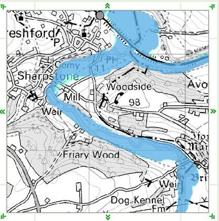
To view a Google satellite image of the mill location visit freshfordsomerset.co.uk and scroll the map due South |
| Revised 1991 | Revised 1978-79 | NB: the buildings occupy 20,000 sq metres thats about five football pitches in area. Or a square of side 140 M |
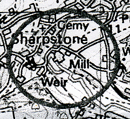 |
Update: May 2008Due to Anne Mcintosh's efforts to resolve this issue some real progress has been made with the problem. Whilst restating that the existing mapping (on which the Environment Agency add their data for the Flood Maps) is within the specification for the OS 1:50,000 series of maps Vanessa Lawrence the CEO of the OS has decided to ask for a modification of the mapping for Freshford Mill. I have seen the revised mapping -on the left- and confirm that it will satisfactorily represent the Freshford Mill group of buildings when the Flood Maps are updated by the Environment Agency. The revision even shows the mill straddling the mill leat and the bulk of the buildings has also been reduced so as to be represented closer to the river Frome. |
|